 Yosemite, Kings Canyon, and Sequoia National Parks and the southern Sierra

Six to eight days • 400-500 miles • 29,000’—45,000′
Tour packet: 43 pages; 48 photos, 8 maps
Download tour preview booklet as pdf (1.3 mb)
For spectacular scenery on the grandest possible scale, it’s hard to beat this tour through three of the most magnificent national parks in the country. It also happens to be one of the more challenging routes in this collection, with lots of climbing, but worth every drop of sweat and every aching muscle. And as you’ll notice in reading the elevation numbers, there is more descending than climbing…and what descending! Some of these downhills are so long and so exciting, you’ll have to stop half-way down to rest and recover your wits.
The tour begins at Twin Lakes near the town of Bridgeport. (For trekkers coming up from the south, we offer an alternate beginning near Mammoth.) For openers, it climbs up and over Conway Summit on Highway 395, setting the tone for the days ahead: up and down, over and over. (The southerners do the Mammoth scenic bypass and the pretty June Lake loop instead.) After a run along 395 to Mono Lake, both routes converge near Lee Vining and turn uphill toward Tioga Pass and the backdoor, upstairs entrance to Yosemite National Park. The route then winds along the pristine, alpine roof of the park before descending into legendary Yosemite Valley.
It takes most of the next three days to connect Yosemite to Kings Canyon National Park. The between-parks route travels via Bass Lake, Pine Flat Lake, and a series of quiet, pretty byways. (You may come on this tour for the sights in the marquee national parks, but these little roads through the middle of nowhere will provide you with some of the nicest miles and most vivid memories of the tour.) After an incredible descent into awesome Kings Canyon—the deepest gorge in the United States—you climb back up to the wonderful Generals Highway linking Kings Canyon to Sequoia National Park…a cycling dream road through the big trees, culminating with a wild, 30-mile downhill to Three Rivers, just beyond the southern edge of the park.
This tour can be modified to work with indoor lodgings. Some of the lodgings will be very near the originally designated campgrounds—in Yosemite Valley, for instance—while others may be a few miles away and require minor adjustments to the routes.
Day 1: Twin Lakes to Tuolumne Meadows
52 miles, 5000′ up, 2300′ down
Bonus miles: 16 miles, 1700′, 12 miles, 1200′
For those arriving from the north on Hwy 395. Drop from Twin Lakes to the town of Bridgeport and head south on Hwy 395, up to Conway summit and down to Mono Lake and Lee Vining. Two optional out-&-backs on scenic side roads. Then climb for 12 miles to 9945’ Tioga Pass—one of the highest paved roads in Califonia—before descending to camp. Showers are two miles from camp at Tuolumne Lodge. (Access to these showers is tricky. One way to ensure access to them: stay at the lodge.) There are other lodgings closer to the park entrance at Tioga Pass.
Day 1 (alternate): Mammoth to Tuolumne Meadows
Mammoth: 55 miles, 3700′ up, 2300′ down
For those driving up from the south on Hwy 395, a start near Mammoth at a full-service camp. Head north to Tioga Pass on the Mammoth Scenic Loop, the June Lake Loop, and stretches of 395.
Day 2: Tuolumne Meadows to Yosemite Valley
58 miles, 2400′ up, 7100′ down
Spectacular scenery at every turn as you cross Yosemite’s alpine attic before descending into one of the most mythic spots on Earth. Downhills dominate all day, culminating in the 13-mile free fall into the valley. Camp in one of several camps at the east end of the valley. Showers at nearby Curry Village. Consider a layover day in the valley. Explore the wonders of Yosemite Valley’s towering granite walls and domes and its plunging waterfalls. So many sights to see!
Day 3: Yosemite Valley to Bass Lake
58 miles, 4500’ up, 5000’ down
Three long climbs and three long descents make up almost the entire route today, with nearly level runs along Yosemite Valley at the start and along Bass Lake at the end. Ride through a mile-long tunnel, visit the old Wawona Hotel, and have a ball on the long downhills. Camp in one of two forest service camps on the lake…perfect for swimming. Showers at a nearby private resort. There are many lodges and resorts around the lake if you wish to stay indoors.
Day 4: Bass Lake to Choinumni
71 miles, 5700′ up, 8300′ down
58 miles, 3200′ up, 5300′ down
The only day on the tour with longer and shorter options. Winds through the pretty Sierra foothills between the national parks. Miles and miles of dinky, empty back roads that you will enjoy as much as the marquee attractions in the big parks. Camp in a very pleasant, quiet county park on the Kings River. No showers, but easy river access for swimming. (The first time we camped here, the river was freezing; the second time, it was quite pleasant. Go figure…) There is indoor lodging about four miles beyond the camp in Wonder Valley, early on tomorrow’s stage. It makes today’s stage a bit longer and tomorrow’s hard stage a bit shorter.
Day 5: Choinumni to Kings Canyon
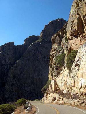
75 miles, 10,000′ up, 5600′ down
Probably the hardest day on the tour, but also one of the most spectacular. Starts with more little lanes along the approach to the park…short, steep climbs and longer, more gradual ones. Far more climbing than the assault on Tioga Pass on Day 1, but the overall impact is not as wearing, perhaps because of the lower altitude. Superb descent into Kings Canyon—the deepest gorge in the U.S.—followed by a beautiful run uphill along the magnificent Kings River to camp. Showers nearby in Cedar Grove village. If you have the time, it might be worthwhile to take another layover day in Kings Canyon. You can probably use the rest, and there are many more things to see and do here than can be squeezed into what’s left of your day after this long ride. (Note: on our first tour, we took a layover day in Yosemite, but on the second tour, we took it here. In retrospect, this makes more sense.)
Day 6: Kings Canyon to Three Rivers
89 miles, 7500’ up, 11,000’ down
Begin with a dream downhill for the first ten miles of the ride, then work your way back up out of Kings Canyon with 25 miles of uphill in the next 40 miles (all gradual), past Hume Lake and south along the Generals Highway into Sequoia National Park. Visit the grand old trees that give the park its name, and then get ready: the final 30 miles of the stage are almost entirely downhill. A large chunk of this constitutes one of the greatest descents in the world: 6000’ of drop in 25 miles of writhing, switch-backing excitement. There is a camp on the Kaweah River at the finish, which we used on our first tour here. But on a second tour, we opted for a very nice inn on the river, discussed in the copy.
